


M72 - New Albany/Union County
Located in New Albany, United States
ICAO - M72, IATA -
Data provided by AirmateGeneral information
Coordinates: N34°32'56" W89°1'28"
Elevation is 413 feet MSL.
Magnetic variation is -01° East View others Airports in Mississippi
Operational data
Special qualification required
Current time UTC:
Current local time:
Communications frequencies: [VIEW]
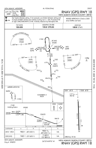
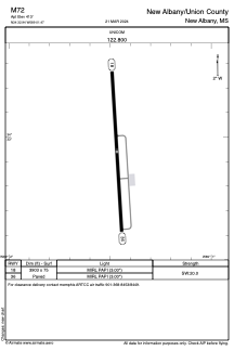
Runways:
| RWY identifier | QFU | Length (ft) | Width (ft) | Surface | LDA (ft) |
| 18 | 176° | 3903 | 75 | ASPH | |
| 36 | 356° | 3903 | 75 | ASPH |
Airport contact information
Address: New Albany United States