
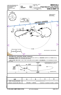
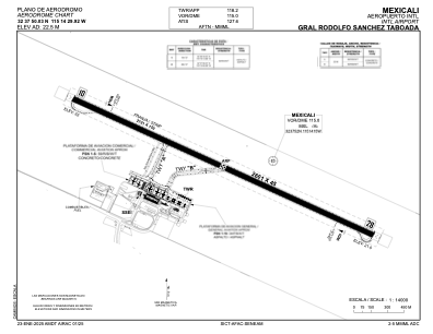


MMML - Mexicali Aeropuerto Int. Gral. Rodolfo Sanchez Taboada
Located in Mexicali, Mexico
ICAO - MMML, IATA - MXL
Data provided by AirmateGeneral information
Coordinates: N32°37'50" W115°14'30"
Elevation is 74 feet MSL.
View others Airports in Baja California
Operational data
Special qualification required
Current time UTC:
Current local time:
Communications frequencies: [VIEW]
Runways:
| RWY identifier | QFU | Length (ft) | Width (ft) | Surface | LDA (ft) |
| 10 | 117° | 8533 | 148 | CON | |
| 28 | 297° | 8533 | 148 | CON |
Airport contact information
Address: Mexicali Mexico