


MMZM - Zamora, Mich
Located in Zamora, Mexico
ICAO - MMZM, IATA - ZMM
Data provided by AirmateGeneral information
Coordinates: N20°2'40" W102°16'32"
Elevation is 5141 feet MSL.
View others Airports in Michoacin
Operational data
Special qualification required
Current time UTC:
Current local time:
Communications frequencies: [VIEW]
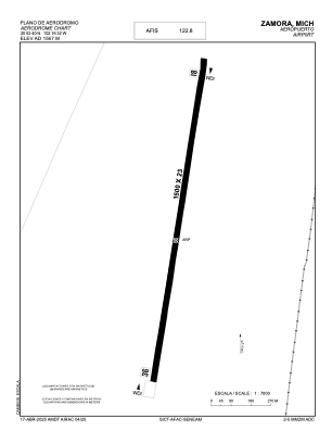
Runways:
| RWY identifier | QFU | Length (ft) | Width (ft) | Surface | LDA (ft) |
| 18 | 188° | 4921 | 75 | ASP | |
| 36 | 8° | 4921 | 75 | ASP |
Airport contact information
Address: Zamora Mexico