


OH71 - Troy Skypark
Located in Troy, United States
ICAO - OH71, IATA -
Data provided by AirmateGeneral information
Coordinates: N39°59'26" W84°16'15"
Elevation is 930 feet MSL.
Magnetic variation is -04° East View others Airports in Ohio
Operational data
Special qualification required
Current time UTC:
Current local time:
Communications frequencies: [VIEW]
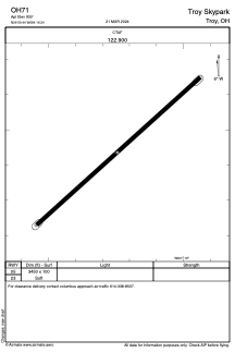
Runways:
| RWY identifier | QFU | Length (ft) | Width (ft) | Surface | LDA (ft) |
| 05 | 48° | 3450 | 100 | GRASS | |
| 23 | 228° | 3450 | 100 | GRASS |
Airport contact information
Address: Troy United States