
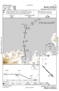
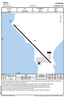


PADU - Unalaska
Located in Unalaska,
ICAO - DUT, IATA - DUT
Data provided by AirmateGeneral information
Coordinates: N53°53'56" W166°32'42"
Elevation is 23 feet MSL.
Magnetic variation is 09° East View others Airports in Alaska
Operational data
Special qualification required
Current time UTC:
Current local time:
Communications frequencies: [VIEW]
Runways:
| RWY identifier | QFU | Length (ft) | Width (ft) | Surface | LDA (ft) |
| 13 | 136° | 4500 | 100 | ASPH | 3900 |
| 31 | 316° | 4500 | 100 | ASPH | 3900 |
Airport contact information
Address: Unalaska