
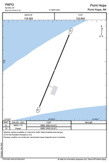


PAPO - Point Hope
Located in Point Hope,
ICAO - PHO, IATA - PHO
Data provided by AirmateGeneral information
Coordinates: N68°20'53" W166°47'57"
Elevation is 20 feet MSL.
Magnetic variation is 06° East View others Airports in Alaska
Operational data
Special qualification required
Current time UTC:
Current local time:
Communications frequencies: [VIEW]
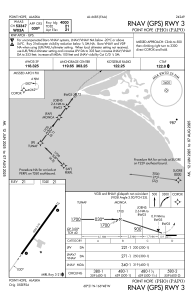
Runways:
| RWY identifier | QFU | Length (ft) | Width (ft) | Surface | LDA (ft) |
| 03 | 36° | 4000 | 75 | ASPH | |
| 21 | 216° | 4000 | 75 | ASPH |
Airport contact information
Address: Point Hope