
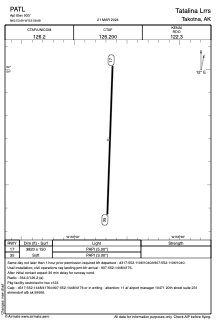


PATL - Tatalina Lrrs
Located in Takotna,
ICAO - TLJ, IATA - TLJ
Data provided by AirmateGeneral information
Coordinates: N62°53'42" W155°58'41"
Elevation is 933 feet MSL.
Magnetic variation is 12° East View others Airports in Alaska
Operational data
Special qualification required
Current time UTC:
Current local time:
Communications frequencies: [VIEW]
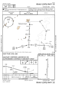
Runways:
| RWY identifier | QFU | Length (ft) | Width (ft) | Surface | LDA (ft) |
| 17 | 182° | 3820 | 150 | GRAVEL | |
| 35 | 2° | 3820 | 150 | GRAVEL |
Airport contact information
Address: Takotna