


PHLI - Lihue
Located in Lihue,
ICAO - LIH, IATA - LIH
Data provided by AirmateGeneral information
Coordinates: N21°58'34" W159°20'20"
Elevation is 152 feet MSL.
Magnetic variation is 11° East View others Airports in Hawaii
Operational data
Special qualification required
Current time UTC:
Current local time:
Communications frequencies: [VIEW]
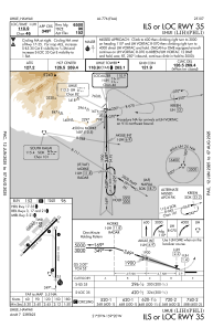
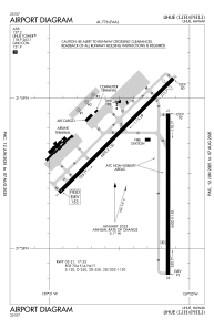
Runways:
| RWY identifier | QFU | Length (ft) | Width (ft) | Surface | LDA (ft) |
| 03 | 45° | 6500 | 150 | ASPH | 6500 |
| 21 | 225° | 6500 | 150 | ASPH | 6295 |
| 17 | 180° | 6500 | 150 | ASPH | 6500 |
| 35 | 360° | 6500 | 150 | ASPH | 6500 |
| H1 | 0° | 0 | 0 | UNK | |
| H2 | 0° | 0 | 0 | UNK | |
| H3 | 0° | 0 | 0 | UNK |
Airport contact information
Address: Lihue
