


PHOG - Kahului
Located in Kahului,
ICAO - OGG, IATA - OGG
Data provided by AirmateGeneral information
Coordinates: N20°53'55" W156°25'50"
Elevation is 55 feet MSL.
Magnetic variation is 11° East View others Airports in Hawaii
Operational data
Special qualification required
Current time UTC:
Current local time:
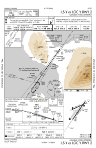
Communications frequencies: [VIEW]
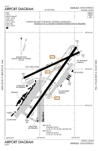
Runways:
| RWY identifier | QFU | Length (ft) | Width (ft) | Surface | LDA (ft) |
| 02 | 35° | 6998 | 150 | ASPH | 6995 |
| 20 | 215° | 6998 | 150 | ASPH | 6995 |
| 05 | 65° | 4980 | 150 | ASPH | 4990 |
| 23 | 245° | 4980 | 150 | ASPH | 4990 |
| H1 | 0° | 0 | 0 | UNK |
Airport contact information
Address: Kahului
