

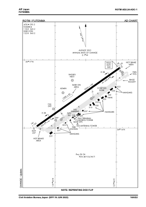


ROTM - Futenma
Located in Naha, Japan
ICAO - ROTM, IATA -
Data provided by AirmateGeneral information
Coordinates: N26°16'15" E127°44'53"
Elevation is 248 feet MSL.
View others Airports in Okinawa Prefecture
Operational data
Special qualification required
Current time UTC:
Current local time:
Communications frequencies: [VIEW]
Runways:
| RWY identifier | QFU | Length (ft) | Width (ft) | Surface | LDA (ft) |
| 06 | 55° | 9004 | 150 | ASP | |
| 24 | 235° | 9004 | 150 | ASP |
Airport contact information
Address: Naha Japan