


RPSP - Bohol-Panglao Airport
Located in Bohol, Philippines
ICAO - , IATA -
Data provided by AirmateGeneral information
Coordinates: N9°34'26" E123°46'14"
Elevation is 42 feet MSL.
Magnetic variation is -2° East View others Airports in Bohol
Operational data
Special qualification required
Current time UTC:
Current local time:
Communications frequencies: [VIEW]
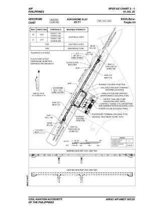
Runways:
| RWY identifier | QFU | Length (ft) | Width (ft) | Surface | LDA (ft) |
| 03 | 31° | 8596 | 148 | ASPH | 8202 |
| 21 | 211° | 8596 | 148 | ASPH | 8202 |
Airport contact information
Address: Bohol Philippines