


S37 - Smoketown
Located in Smoketown, United States
ICAO - S37, IATA -
Data provided by AirmateGeneral information
Coordinates: N40°2'30" W76°12'7"
Elevation is 370 feet MSL.
Magnetic variation is -11° East View others Airports in Pennsylvania
Operational data
Special qualification required
Current time UTC:
Current local time:
Communications frequencies: [VIEW]
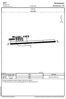
Runways:
| RWY identifier | QFU | Length (ft) | Width (ft) | Surface | LDA (ft) |
| 10 | 0° | 2750 | 50 | ASPH | |
| 28 | 0° | 2750 | 50 | ASPH |
Airport contact information
Address: Smoketown United States
