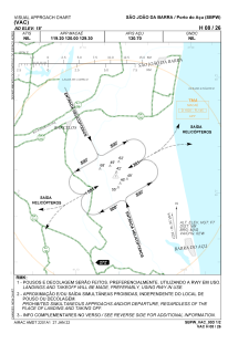
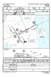


SBPW - Porto Do Açu
Located in São João Da Barra, Brazil
ICAO - SBPW, IATA -
Data provided by AirmateGeneral information
Coordinates: S21°48'15" W41°6'32"
Elevation is 18 feet MSL.
Magnetic variation is -23.683333333° East View others Airports in Rio de Janeiro
Operational data
Special qualification required
Current time UTC:
Current local time:
Communications frequencies: [VIEW]
Runways:
| RWY identifier | QFU | Length (ft) | Width (ft) | Surface | LDA (ft) |
| 08 | 0° | 1243 | 103 | UNK | |
| 26 | 0° | 1243 | 103 | UNK |
Airport contact information
Address: São João Da Barra Brazil