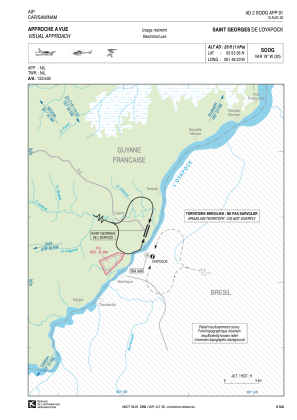


SOOG - Saint Georges De L'oyapock
Located in Saint Georges, French Guiana
ICAO - SOOG, IATA - OYP
Data provided by AirmateGeneral information
Coordinates: N3°53'36" W51°48'20"
Elevation is 29 feet MSL.
Magnetic variation is -18.68° East View others Airports in Cayenne
Operational data
Special qualification required
Current time UTC:
Current local time:
Communications frequencies: [VIEW]
Runways:
| RWY identifier | QFU | Length (ft) | Width (ft) | Surface | LDA (ft) |
| 04 | 18° | 3937 | 49 | ASPH | 3937 |
| 22 | 198° | 3937 | 49 | ASPH | 3937 |
Airport contact information
Address: Saint Georges French Guiana