

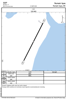


SXP - Nunam Iqua
Located in Nunam Iqua,
ICAO - SXP, IATA -
Data provided by AirmateGeneral information
Coordinates: N62°31'13" W164°50'52"
Elevation is 17 feet MSL.
Magnetic variation is 08° East View others Airports in Alaska
Operational data
Special qualification required
Current time UTC:
Current local time:
Communications frequencies: [VIEW]
Runways:
| RWY identifier | QFU | Length (ft) | Width (ft) | Surface | LDA (ft) |
| 02 | 27° | 3016 | 60 | GRAVEL | |
| 20 | 207° | 3016 | 60 | GRAVEL | |
| 09W | 0° | 15000 | 2000 | WATER | |
| 27W | 0° | 15000 | 2000 | WATER | |
| 18W | 0° | 15000 | 2000 | WATER | |
| 36W | 0° | 15000 | 2000 | WATER |
Airport contact information
Address: Nunam Iqua