

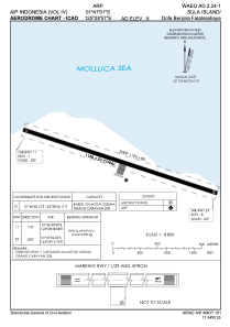


WAEO - Sula Island/Dofa Benjina Falabisahaya
Located in , Indonesia
ICAO - , IATA - MAL
Data provided by AirmateGeneral information
Coordinates: S1°46'56" E125°28'56"
Elevation is 10 feet MSL.
Magnetic variation is 0° East View others Airports in Maluku Utara
Operational data
Special qualification required
Current time UTC:
Current local time:
Communications frequencies: [VIEW]
Runways:
| RWY identifier | QFU | Length (ft) | Width (ft) | Surface | LDA (ft) |
| 11 | 109° | 3773 | 75 | UNK | |
| 29 | 289° | 3773 | 75 | UNK |
Airport contact information
Address: Indonesia