
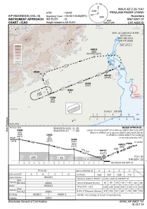
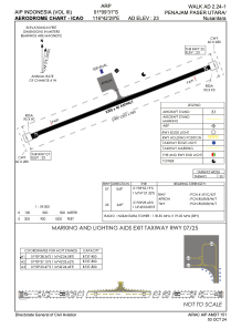


WALK - Penajam Paser Utara / Nusantara
Located in Penajam Paser Utara, Indonesia
ICAO - WALK, IATA - BEJ
Data provided by AirmateGeneral information
Coordinates: S1°9'31" E116°42'29"
Elevation is 23 feet MSL.
View others Airports in East Kalimantan
Operational data
Special qualification required
Current time UTC:
Current local time:
Communications frequencies: [VIEW]
Runways:
| RWY identifier | QFU | Length (ft) | Width (ft) | Surface | LDA (ft) |
| 07 | 69° | 7218 | 148 | UNK | |
| 25 | 249° | 7218 | 148 | UNK |
Airport contact information
Address: Penajam Paser Utara Indonesia