
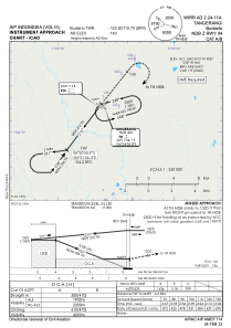
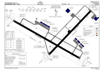


WIRR - Tangerang / Budiarto
Located in Tangerang, Indonesia
ICAO - , IATA -
Data provided by AirmateGeneral information
Coordinates: S6°17'36" E106°34'5"
Elevation is 140 feet MSL.
View others Airports in Banten
Operational data
Special qualification required
Current time UTC:
Current local time:
Communications frequencies: [VIEW]
Runways:
| RWY identifier | QFU | Length (ft) | Width (ft) | Surface | LDA (ft) |
| 12 | 120° | 6562 | 148 | UNK | |
| 30 | 300° | 6562 | 148 | UNK | |
| 04 | 44° | 5249 | 148 | UNK | |
| 22 | 224° | 5249 | 148 | UNK |
Airport contact information
Address: Tangerang Indonesia