


X51 - Miami Homestead General Aviation
Located in Homestead, United States
ICAO - X51, IATA -
Data provided by AirmateGeneral information
Coordinates: N25°29'57" W80°33'15"
Elevation is 7 feet MSL.
Magnetic variation is -06° East View others Airports in Florida
Operational data
Special qualification required
Current time UTC:
Current local time:
Communications frequencies: [VIEW]
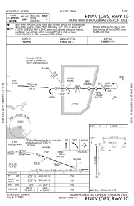
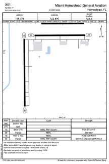
Runways:
| RWY identifier | QFU | Length (ft) | Width (ft) | Surface | LDA (ft) |
| 09U | 0° | 2500 | 150 | GRASS | |
| 27U | 0° | 2500 | 150 | GRASS | |
| 10 | 90° | 3000 | 75 | ASPH | |
| 28 | 270° | 3000 | 75 | ASPH | |
| 18 | 179° | 4001 | 100 | ASPH | |
| 36 | 359° | 4001 | 100 | ASPH | |
| 09 | 0° | 2500 | 150 | UNK | |
| 27 | 0° | 2500 | 150 | UNK |
Airport contact information
Address: Homestead United States
Other aviation service providers
Flight schools

Pilot Training Center Homestead
Pilot Training Center Homestead
bryan@pilottrainingcenterhomestead.com+1(786)309-2359