


YRID - Riddell
Located in Riddell's Creek, Australia
ICAO - YRID, IATA -
Data provided by AirmateGeneral information
Coordinates: S37°28'41" E144°43'18"
Elevation is 1155 feet MSL.
Magnetic variation is 11° East View others Airports in Victoria
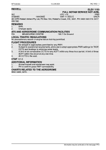
Operational data
Special qualification required
Current time UTC:
Current local time:
Communications frequencies: [VIEW]
Runways:
| RWY identifier | QFU | Length (ft) | Width (ft) | Surface | LDA (ft) |
| 02 | 31° | 2686 | 28 | ASPH | |
| 20 | 211° | 2686 | 28 | ASPH |
Airport contact information
Address: Riddell's Creek Australia